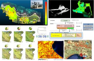
aglab2

AG Lab

Lab full name
"Applied Geomatics" laboratory
ERC 2nd Level Code
Research Activities

Services and research activities (institutional and funded) provided within the lab focus on the
following Geomatics themes:
• extraction of 2D/3D geometric primitives from satellite/aerial/UAV VHR data to update
Technical/Thematic Cartography.
• multi-temporal (change detection) classification of satellite data acquired by means of optic
sensors with medium and high spatial, radiometric and spectral resolution to produce
thematic maps (land use/land cover, vegetation, thermal anomalies, archaeological traces,
etc.);
• development and customization, through open and proprietary programming languages, of
specific algorithms for processing 2D/3D data aimed at improving qualitative and quantitative
standards (geometry, accuracy and precision) of results;
• pre/post-processing and structuring of complex 3D cartographic objects, obtained by means
of laser technologies for aerial (LIDAR) and Terrestrial LASER Scanning, UAV systems
(structure from motion and photogrammetric restitution) aimed generating altimetric
models for environmental modelling (DTM, DMS, DEM, etc.);
• development and implementation of WebGIS systems (FLOSS and proprietary software) for
interactive analysis, representation and sharing of Big 2D/3D geospatial data according to
OGC standard through ad hoc WMS/WFS-T services;
• Accuracy testing on geospatial data produced by third parties (technical cartography, LU/LC
classification accuracy, specific land cover extraction);
• Stability testing of WebGIS systems and services implemented by third parties

Department
Contact Person
Companies and Institutions
- Corvallis S.p.A.
- Autorità di Bacino della Puglia
- SIPAL S.p.A.
- ARPA Puglia
- University of Almeria (Spagna)
- Cyprus University of Technology (Cipro)
- Technical University of Lodz (Polonia)
- Latvia University of Life Sciences and Technology (Lettonia)
- Centre for Advanced Mediterranean Agronomic Studies - CIHEAM
- Istituto di Metodologie per l'Analisi Ambientale (IMAA) del Consiglio Nazionale delle Ricerche
- University of Warmia and Mazury (Polonia)
- Eratosthenes Centre of Excellence (ECoE)
- ASSET Regione Puglia
- University of Bucharest, Faculty of Geography (Romania)
- Regione Puglia, SEZIONE GESTIONE SOSTENIBILE E TUTELA DELLE RISORSE FORESTALI E NATURALI
Projects
- GreenhouseSat "Object-based horticultural crop under greenhouse identification using stereo imagery of WorldView-3 satellite and Landsat 8 time-series"
- STIMARE "STrategie Innovative, Monitoraggio ed Analisi del Rischio Erosione"
- CONVENZIONE DI RICERCA SIPAL-DICATECh “Cantiere tecnologico per infrastrutture Civili e Militari” Responsabile Eufemia Tarantino
- AIM: Attrazione e Mobilità Internazionale "Definizione di un sistema integrato di monitoraggio per la definizione della influenza dei SOD sui ROD in centri storici"
- Sentinel-GH (RTI2018-095403-B-I00; MAPEADO DE INVERNADEROS E IDENTIFICACION DE CULTIVOS HORTICOLAS PROTEGIDOS MEDIANTE ANALISIS DE IMAGEN BASADA EN OBJETOS Y SERIES TEMPORALES DE IMAGENES DE SATELITE) - Spagna
- BRAINS TO SOUTH 2018 "EO4SDG - Earth Observation for Sustainable Development Goals: Big Data analytics for monitoring global land changes phenomena" - Responsabile scientifico Andrea Nascetti
- ACCORDO con ASSET Regione Puglia - STUDIO E GESTIONE DEL MONITORAGGIO GEOMATICO IN TEMPO REALE DELL’AREA IN FRANA DEL VERSANTE OCCIDENTALE PRESSO L’ABITATO DI CHIEUTI (FG) - Responsabili: Eufemia Tarantino e Alberico Sonnessa
- COASTLINE - HORIZON-MSCA-2022-SE-01 - 2024-'27 - Responsabile scientifico: Alessandra Capolupo
- ACCORDO con Regione Puglia - 2023 -RES4SEAL (REMOTE SENSING FOR SEA LITTER) - Responsabile scientifico: Eufemia Tarantino
- WIN-RIESCO - From vines to WINes: managing RIsks to Enhance Sustainability and COntinuity - PRIN 2022 PNRR: PROGETTI DI RICERCA DI RILEVANTE INTERESSE NAZIONALE – Responsabile scientifico Unità locale: Alessandra Capolupo
- AquaRevive - Bando Scoperta imprenditoriale PON 2021/2027 - MIMIT - Responsabile scientifico: Eufemia Tarantino
Softwares
- "AssesSeg Tool" (to measure the goodness of a segmentation by means a modification of Euclidean Distance 2 index)
Hours
From Monday to Friday from 9:00 to 13:30